
Updated June 2026
Rock River VermontVisitor guide near Newfane & Brattleboro
Route 30 parking, trail map, and live conditions—check before you drive.
Real river days
Summer here looks like this
Warm water, easy company, and a lot of smiles — come see why people keep coming back.


On the trail
Bring your people
The walk in is half the fun — friends, dogs, and good light the whole way to the water.


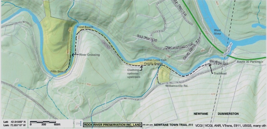
Rock River Vermont is a southern Vermont river and swimming-hole corridor near Newfane, Dummerston, and Brattleboro. Most visitors orient by VT Route 30 near Depot Road and use marked public pull-offs only. This independent guide helps visitors check the map, parking, directions, current conditions, water safety, preservation guidance, LGBTQ-friendly and clothing-optional context, nearby towns, and common visitor questions.
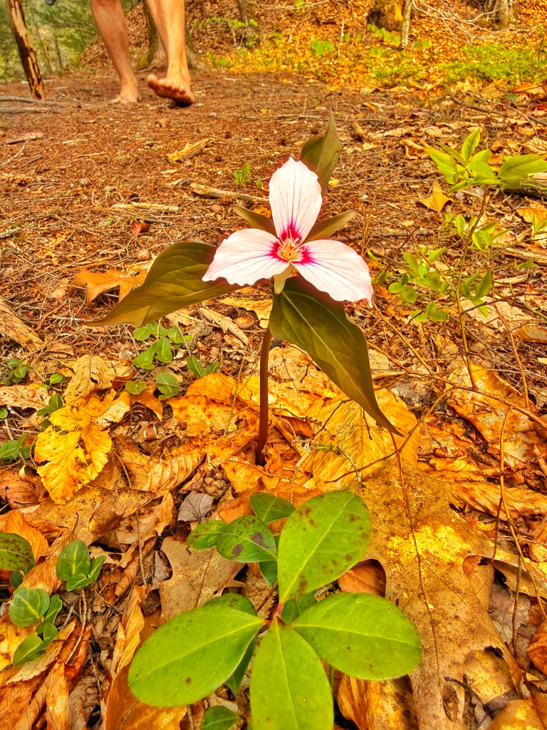
Spotted on the trail
A painted trillium on the Rock River trail
The walk in is part of the trip. Spring and early summer bring painted trillium, ferns, and woodland flowers along the path before the river opens up. Tread lightly, stay on the route, and leave wildflowers where they grow so the next visitor sees them too.
Should you head out?
Live weather, parking, and river readouts load when you scroll here or after the hero settles—static planning copy stays visible for search either way.
Popular searches
What people look for on Rock River Vermont
Rock River today
Memorial Day weekend pace
Warm afternoons pull more cars to Route 30 pull-offs. Water can still run cold and fast after rain, so read the bank before you wade and plan a backup if parking is full.
Rock River Vermont quick answer
Rock River Vermont: where it is, how to visit, and what to check first
Rock River Vermont usually means the southern Vermont swimming-hole corridor near Newfane and Dummerston, a short drive from Brattleboro. Visitors use the Route 30 / Depot Road area for legal parking, then walk an uneven woodland trail toward cold pools, ledges, and preserved riverbank.
This site is an independent, neighbor-run visitor guide for planning a respectful Rock River visit. Use it for the map, parking notes, current conditions, trail overview, water-safety reminders, privacy-first etiquette, LGBTQ-friendly visitor context, and what to check before you drive.
Rock River has a long LGBTQ-friendly and clothing-optional history, but it is still a shared natural place first. Check conditions, use marked parking only, avoid photos of strangers, keep voices low, pack out everything, and follow posted signs and steward guidance.
This guide is about the southern Vermont Rock River near Newfane, Dummerston, Route 30, Depot Road, Brattleboro, and the West River. It is not the northern Rock River connected with Franklin, Highgate, Quebec, Missisquoi Bay, or Lake Champlain.
Quick facts
- Place
- Rock River, southern Vermont
- Common searches
- Rock River Vermont, Rock River VT, Rock River Newfane, Rock River Dummerston
- Nearby towns
- Newfane, Dummerston, Brattleboro
- Practical access phrase
- Route 30 near Depot Road
- Main visitor use
- Swimming holes, rocky pools, ledges, short walk-in trail
- Parking
- Marked public pull-offs only
- Trail
- Uneven woodland trail with roots, wet stone, mud, and ledge
- Facilities
- No restrooms, showers, trash cans, vendors, or lifeguards
- Culture
- LGBTQ-friendly history, privacy-first etiquette, shared natural shoreline
- Before you go
- Check rain, flow, clarity, parking, daylight, signs, and current conditions
Common questions
Rock River Vermont FAQ
- Where is Rock River Vermont?
- Rock River Vermont is in southern Vermont, in Windham County, near Newfane, Dummerston, and Brattleboro. Most visitors mean the lower Rock River swimming-hole corridor reached from the Route 30 / Depot Road area.
- Is Rock River in Newfane or Dummerston?
- Both names appear in searches because the river, parking references, and nearby roads span town labels. For visiting, the practical phrase is Route 30 near Depot Road. Use the map, legal pull-offs, posted signs, and current guidance.
- Where do I park for Rock River?
- Use marked public pull-offs near Route 30 and Depot Road. Do not block driveways, gates, road paint, shoulders, or emergency access. If legal parking is full, choose another time or another plan.
- Is Rock River a swimming hole?
- Yes. Visitors know the lower Rock River corridor for cold pools, rocky ledges, sandy banks, and clear swimming-hole areas. Conditions change quickly after rain, storms, spring runoff, and heavy weekend use.
- Is Rock River LGBTQ-friendly?
- Yes. Rock River has a long LGBTQ-friendly history. The best way to honor that history is simple: protect privacy, avoid photos of strangers, give people room, keep voices low, and follow posted signs.
- Is Rock River clothing optional?
- Some areas have a long clothing-optional history, but posted signs, steward guidance, privacy, and local norms come first. Do not assume every stretch is the same.
- Are there bathrooms or lifeguards?
- No. Plan before arriving. There are no on-site restrooms, showers, vendors, trash cans, or lifeguards.
- What should I check before going?
- Check current weather, recent rain, water clarity, flow, daylight, parking, trail footing, and posted signs. No website can clear a natural river for swimming, so trust what you see at the bank.
- Is this the same Rock River as the northern Vermont Rock River?
- No. This guide covers the southern Vermont Rock River near Newfane, Dummerston, Brattleboro, Route 30, Depot Road, and the West River. It is not the northern Rock River tied to Franklin, Highgate, Quebec, Missisquoi Bay, or Lake Champlain.
Source transparency
Why this guide exists
RockRiverVT is an independent, visitor-run, privacy-first guide. It is not the town, state, Rock River Preservation, or any official access manager. We link to stewardship groups, town notices, and regional water-quality resources so you can verify facts and plan a careful visit.